Lahaul & Spiti
Lahaul & Spiti
Best Lahaul & Spiti Tour Package in India – Igloo Camp Travels
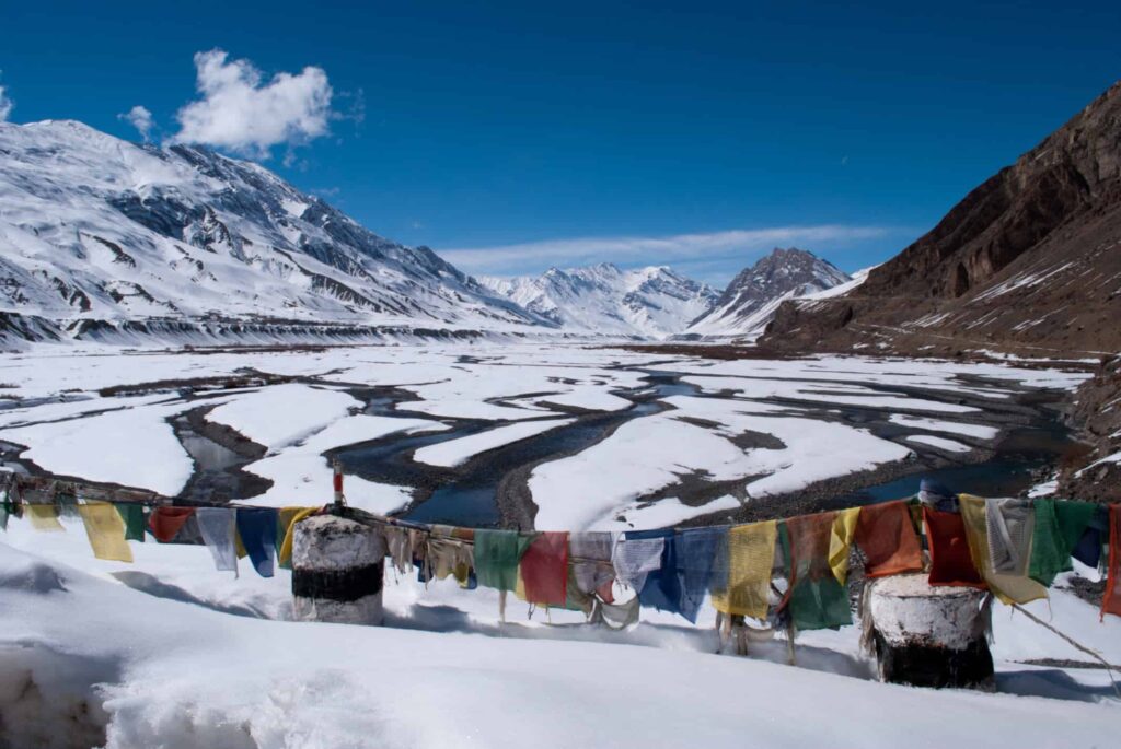
These valleys are cut off from the rest of the rest of the world for half of the year. When they again emerge during the other half of the year through the melting snow, the sight is breathtaking and awe inspiring with barren Himalayan deserts and sparkling rivers in view.
Kaza
Situated at an altitude of 3600 meter above sea level on the left bank of river Spiti is presently the headquarters of Spiti sub division. Translated, ‘Spiti’ means the ‘middle country’ – a name obviously given as a result of its ties with both India and Tibet. With freckles of green over a dry, weather-beaten face, Spiti is a cold desert where the monsoon rain never comes. It is characterised by stark beauty, narrow valleys and high mountains. A century ago, Rudyard Kipling in Kim called Spiti “a world within a world” and a “place where the gods live” – a description that holds true to the present day.
210 Km from Kalpa, 47 km from Tabo. The headquarters of Spiti sub-district, Kaza lies on the bank of river Spiti. In earlier times, it was the capital of Nono, the Chief of Spiti. It has a Buddhist Monastery and Hindu Temple.
Langza
Located at an altitude of 14500 feet or 4420 meters, Langza is one of the remotest villages of India in the remote corner of Himachal Pradesh. Greenfields besotted on brown hills and distinctive houses constructed in Tibetan style architecture sums up the pictorial representation of Langza. Envelop this picture with surrounding snow-capped peaks and it completes the breathtaking view of Langza village.
Spitian villages are geographically demarcated into upper and lower parts. Langza is no exception, the lower part of the village is termed Langza Yongma and the upper one is Langza Gongma.

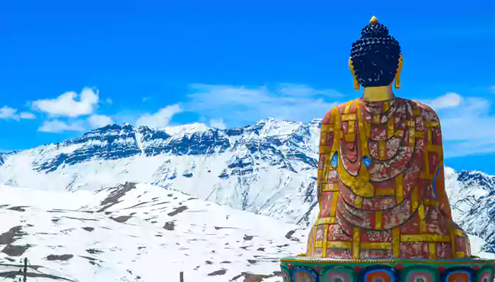
Langza Gongma houses the Lang, a local village temple. A massive statue of Lord Buddha guarding the hamlet is the tallest structure here, which is also the most popular picture of Langza on the internet. Another striking feature of the village – the Chau Chau Kang Nilda peak – adorns its landscape majestically.
Komik,
The picturesque Lahaul and Spiti Valley embraces several treasures in its vicinity and Komik is one such place, which is set beautifully amid the stunning mountains in the state of Himachal Pradesh in North India. Komik Village is the highest village in Asia and is located at a height of 18,000 feet above sea level. The beauty of this place cannot be described in words; it can only be felt and experienced with naked eyes. Surrounded by snowbound mountains and majestic valleys, Komik Village attracts countless tourists who simply want to get drenched in its breathtaking beauty and charming festivity. All you need to do is come and explore the delightful vistas of this scenic valley.
Highlights
Komik Village is famous for Lundup Tsemo Gompa Buddhist Monastery. It is believed that the monastery has ‘Matrey Buddha,’ or ‘the future Buddha,’ who looks after the well being of the people of Komik Village. It is also famous for being the highest motorable Buddhist monastery in the world, visited by bikers and travel enthusiasts from all over the world. The 14th century monastery has a fortified castle made of slanted mud walls, representing the murals, scriptures, and arts belonging to the bygone era.
It is said that even before the monastery was being made, it was already said in Tibet that a monastery in the shape of the eye of a snow cock would be built in a mountainous region in Spiti. Thus, the place was called Komik or Koumik, where ‘Ko’ stands for snow cock and ‘Mik’ means eye.
Other aspects of Komik
For the people of Komik, their village is their world and it is indisputable because the beauty here is so evident that no one, not even an outsider would ever think of leaving this place. This cold deserted village hosts many festivals throughout the year and the same can be enjoyed by tourists who love to see Lamas performing Chham dance or mask dance.
The adventure lovers have other perks of visiting this stunning village. They can trek throughout the region and enjoy the thrilling moments in the exquisite surroundings of Komik. This area is completely cut off from the rest of the country due to heavy snowfall during winter and the local residents store enough food to last the winter season as they avoid getting out of their houses at this time. They use the time in making handicrafts like carpet, shawls, caps, jackets, paintings, etc.
There are basic options for homestay and hotels in Komick, where the food is served by local people with great lovel and that too when ordered in advance. Anyone looking for a luxury stay can opt for Kaza. Komik can be best visited during summer from May to October as the routes from Rohtang Pass remain open at this time.
Tashigang village in the spiti valley
Tashigang, a beautiful village located at an altitude of 4650 m, has just four homes. To reach here, one has to pass from the Kibber Village, which is at an altitude of 4205 m and 18 km from Kaza. After passing
Tashi Gang is a very small village located in Spiti of Lahul and Spiti district, Himachal Pradesh with a total 6 families residing. The Tashi Gang village has a population of 40 of which 23 are males while 17 are females as per Population Census 2011.
Kibber
you’ll reach the village of Gette and then come to Tashigang. One has to drive ahead from Ki Monastery to reach these villages. There are ancient chortens dotting the walk to the village.
Tashi Gang is a very small village located in Spiti of Lahul and Spiti district, Himachal Pradesh with a total 6 families residing. The Tashi Gang village has a population of 40 of which 23 are males while 17 are females as per Population Census 2011.
Demul Village
After walking for about six hours with heavy backpacks, we could finally see a village from a hill top at 15,800ft. All exhausted due to less oxygen and heavy load, it was really an amazing moment to see civilization after so long. We reached the village and met Angruup Funchok, the village coordinator of Demul. He makes sure every homestay in the village gets its turn to serve the tourists. Unlike other villages of Spiti, the hospitality in this village is controlled. It works like a taxi union. You cannot choose a home stay. The village coordinator allotted them turn by turn. He explained the rules clearly. The weirdest one was that you cannot stay in one house for more than a night. You have to keep shifting everyday during the period of your stay. This idea was conceptualised by an NGO who did an amazing job of giving the village solar electricity for two hours daily.
Demul is a village tucked safely between high mountains that might have got its name from folklore. A resident of a nearby village lost his Demo (Female Yak). He began searching for it in the
ACCESS : Nearest airports are at Kullu (Bhuntar) 250 km. and Shimla 445 km. Kaza can be approached by road from Shimla (May to October) and from Manali 200 km. via Kuzam Pass (June to October).
CLIMATE : This region is known as Cold Desert and does not receive rainfall. In winter the temperature can drop below freezing point, when heavy woolens are required. In summers the weather remains pleasant when light woolens are advised.
PLACES OF INTEREST
TABO (3050 m): 163 km from Kalpa is the ancient village of Tabo, situated on the left bank of river Spiti. Flanked on either sides by hills, it has one of the most important Buddhist monasteries regarded by many as only next to the Tholing Gompa in Tibet. It is also known as the Ajanta of the Himalayas. Tabo is the largest monastic complex of Spiti which has since been declared a protected monument under the aegis of Archaeological Survey of India.
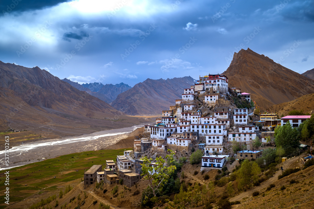
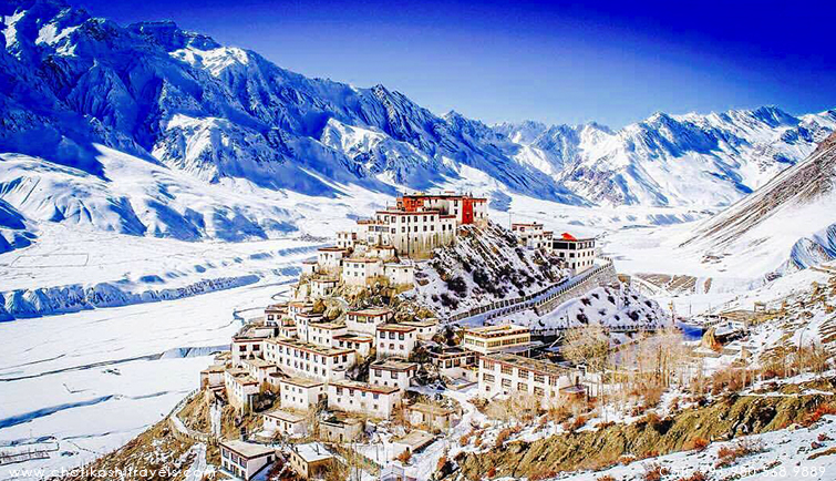
KEY GOMPA (4116m) : 7 km from Kaza. The largest monastery in Spiti Valley. Established in the 11th century has ancient Buddhist scrolls and paintings. It also houses a large number of Buddhist monks and nuns.
KIBBER (4205m) : 18 km from Kaza. The highest village in the world which is connected by motorable road and is the highest habitated village in the world which has its own polling station during elections.
DHANKAR (3890m) : 24 km from Tabo, this place is famous for a Buddhist monastery.
Kunzum Pass, Lahaul & Spiti Valley
The motorbiking enthusiasts are very much familiar with this majestic gateway that leads to Lahaul and Spiti valleys. Situated at a height of 4551 meters above sea level, the Kunzum Pass or Kunzum La is one of India’s highest motorable mountain passes, and is located in Himachal Pradesh in North India. A large number of bikers visit this spot to experience the most thrilling ride through the spectacular gateway of Kunzum Pass. The place is also known for the Goddess Kunjum (Durga/Parvati) temple, which is located on the top of Kunzum and keeps guard over the pass and wards of the evil power.
Highlights
The visitors often take a round of this temple to seek the blessings of Goddess Durga and visit Chandratal Lake, which is only 7 km from Kunzum Pass. This route is so beautiful that people take a halt here to indulge in photography and to view the magnificent Bara-Sigri Glacier, the second largest Glacier in the world. While biking, one can enjoy views of the majestic Chandra Bhaga ranges covered with snow clad peaks and massive glaciers and the Spiti valley that has desert- like terrain. There are no tourist facilities available here; however, the visitors can go to the nearest village ‘Losar,’ which is only 16 kms from Kunzum Pass, to seek accommodation or eatery facilities.
The Kunzum Pass separates Spiti and Lahaul Valley and is situated at a higher altitude than Rohtang Pass. It is one of the most popular and widely used passes by tourists visiting Lahaul, Spiti, and Manali. One can easily notice signs of Buddhist influence in and around Kunzum Pass in the form of prayer flags. Other than bikers, this place is also popular with trekkers and adventure seekers, who take the 12 km trek to Chandratal, which is another popular spot in Lahaul and Spiti Valley.
Although there are no options to stay at this village, tourists can easily find homes that are run by locals, in case they really want to take a halt here.
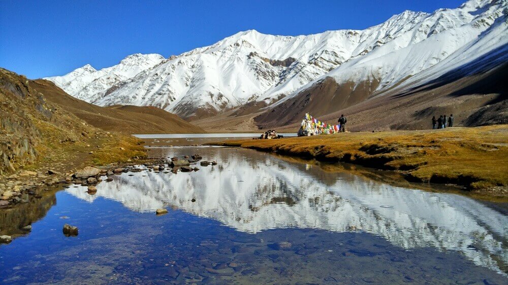
Chandratal Lake, Spiti Valley Overview
A camper and trekker’s paradise, Chandratal Lake is often referred to as one of the most beautiful lakes located at an altitude of about 4300 m in the mighty Himalayas. The stunning lake is situated on the Samudra Tapu plateau which overlooks the Chandra River. The name “Chandra Taal” (Lake of the Moon) comes from its crescent shape. This lake is also one of two high-altitude wetlands of India that have been designated as Ramsar sites. Once a tentative residence for Tibetan traders traveling to Spiti and the Kullu valley, it attracts thousands of adventure enthusiasts from all over the world.
Legend has it that the Chandratal Lake lies in the vicinity of a place from where God Indra’s chariot picked up Yudhishthira, the eldest of Pandava brothers in Mahabharata. This fact renders the lake sacred and thus, is flocked by a lot of Hindu devotees. The colour of water of this holy lake keeps changing from reddish to orange to blue to emerald green as the day ends. Vast stretches of green meadows house the best camping sites and an array of different wildflowers during springtime. The trek from Batal to Chandratal can be quite a tedious trail, but the captivating views and charm of the place will be worth it. The sun’s light reflecting on the surface of the astounding Chandratal Lake makes it seem crystal clear.
KEYLONG
Situated at an altitude of 3350 m, Keylong is the headquarters of Lahaul and Spiti district of Himachal Pradesh. The region is strange, exciting, primitive, mountainous and delightful. Rudyard Kipling said of the region “Surely God lives here, this is no place for men.” The route to Lahaul takes a traveler over Rohtang Pass (3980 ml), Koksar (1st village of Lahaul) Sissu, Gondla and crossing the river Chandra Bhaga at Tandi
ACCESS : By road the distance is 115 km from Manali, 188 km from Kaza, 373 km from Leh, 435 km from Chandigarh and 690 km from Delhi. Heavy winter snows cut off road connectivity to the region at Rohtang Pass for six months from November to June. Buses, Taxis are available from Manali in season. HPTDC also flies regular coaches to Leh via Keylong during July – September. Nearest airport is Bhunter, 175 km from Keylong.
CLIMATE : Lahaul remains cut-off from outside the world till mid June due to heavy snowfall and closing of Rohtang Pass. There is little or no rain in monsoons. The climate remains dry and invigorating. The days are hot and nights are extremely cold. Heavy / Light woolens are recommended.
PLACES OF INTEREST
TANDI (2573m) : 8 km, short of Keylong, on the Manali – Leh Raod, situated on the confluence of Chandra & Bhaga rivers. Last point to tank up if traveling north of Keylong as it has the last fuel station on this stretch.
SISSU (3100m) : On the bank of Chandra, 15 km from Koksar, every spring and autumn wild geese and ducks halt here on their way to and from Siberia.
GONDLA (3110m) : 18 km from Keylong on the right bank of river Chandra. Famous for ancient Fort.
UDAIPUR (2523m) : 53 km from Keylong, home of the Mrikula Devi Temple, which is famous for wood carvings.
TRILOKNATH (2660m) : 4 km from Udaipur famous for Triloknath temple. Sacred both for HIndu and Buddhist.
MONASTERY’S :
Lahaul is well known for its monasteries, locally called Gompas, which are great repositories of Buddhist faith and art treasures. These are Kardang – 5 km, Shasur – 3 km, Guru Ghantal – 8 km, Tayul – 6 km, Gemur – 18 km
SHOPPING : Shawls, Local Tweeds, Caps, Rugs, Footwear, Fresh fruit, Natural oil (olive and almond), Silver jewellery, Pullovers, Metal craft, Woolen jackets and Bamboo products.
SEASON: MAY TO OCT.
DISTANCE: FROM SANGLA OR KALPA. 235 KM VIA AKPA, MORANG, SPELO, KHAB, NAKO , TABO, FROM MANALI, 280 KM, VIA ROHTANG, GARAMPOO, CHOTA DHARA, BATAL, KUNZUMPASS, LOSAR, KAZA
TREKKING ROUTE: FROM KAFNU (KINNAUR) TO MUD 6 DAYS
KUNZAM PASS (4551m) : 76 km. One of the highest motorable passes. Goddess Kunjum keeps guard over this pass and wards off evil.
CHANDERTAL LAKE (4270m) : 7 km from Kunzam Pass, is one of the most beautiful lakes in the entire Himalayan region. Surrounded by snow, this deep blue water lake has a circumference of 2.5 km. River Chandra flows very close to the lake.
IMPORTANT INFORMATION FOR INDIAN AND FOREIGN TOURISTS
The Kinnaur and Spiti area of Himachal Pradesh has been opened to Indian and Foreign tourists. While going via Shimla and Rampur – Kalpa, Recong Peo and Sangla Valley can be visited by Indians and Foreigners without any restrictions. To travel beyond Jangi in Kinnaur to Kaza in Spiti one requires an inner line permit for foreign nationals which can be obtained from the following offices:
District Magistrate – Shimla, Recong Peo (Kinnaur), Kullu, Keylong (Lahaul)
Sub District Magistrate (SDM) – Shimla, Rampur, Kalpa, Nichar, Keylong, Udaipur